| Fort Name : | Alphabetically | RangeWise | DistrictWise | CategoryWise | GradeWise |
| Rajmachi | FortHeight : 3600 | ||||
| Type : Hill forts | Fort Range : Lonavla | ||||
| District : Pune | Grade : Medium | ||||
| The range of Sahyadris which start from Lonavla-Khandala is known as the Ulhas river valley from which the river originates. 15 kms North West from Lonavla is Rajmachi fort located. Bor ghat which passed to Pune connecting the ports of Klayan and Naalasopara was a very important trade route. To protect these trade routes and to collect octroi from the traders many forts were built on the borders of Konkan region and the ghats/passes. Of these forts, Rajmachi was very important and it served a highly powerful place in the military warfare as to its one side falls Mavaal region, Tung, Tikona, Lohagad, Visapur forts and to the other side are Bhimashankar region, Peth, Dhak, Gorakhgad, Chanderi, Siddhagad forts. The two citadels of Rajmachi serve as independent forts in themselves. |
|||||
|
|||||
| Fascinating Spots : | |||||
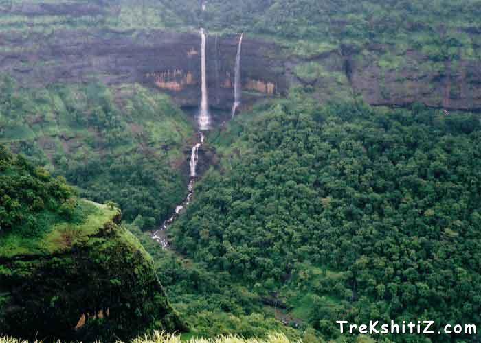
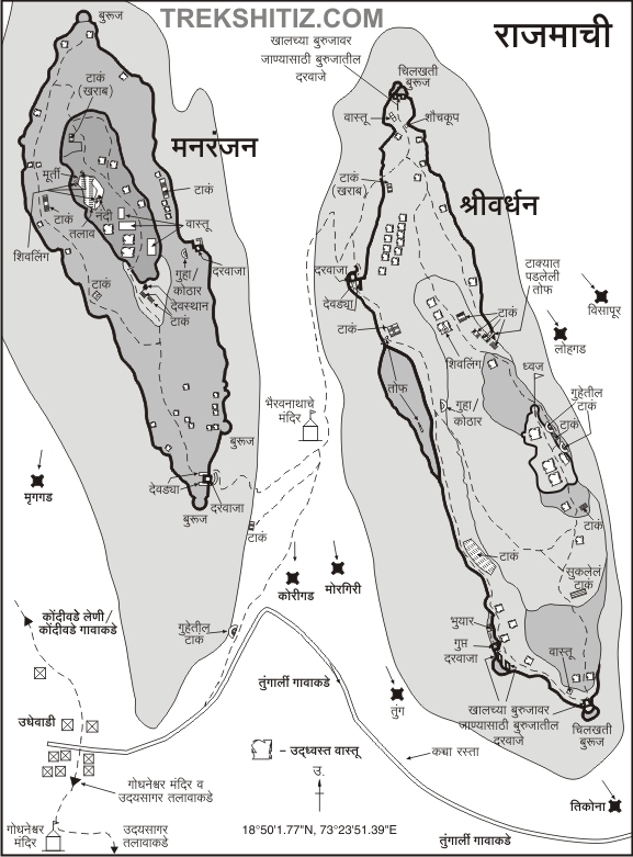
| While approaching Rajmachi from Lonavla via Tungarli we come across a statue of a warrior, devastated fort wall, remnants of the entrance door, idols of Lord Ganesh and Maruti near the village border. The village which is on the fort summit is called Udhewadi. The deep valley which is on the east and south of Rajmachi is called as “Kataldara” and its home to a splendid waterfall in the rainy season. Ulhas river originates from this area. The hill to the west of the river is called Bhairav hill. The fort has two citadels – Shrivardhan and Manranjan. On the ridge between these two citadels there is a Lord Bhairavnath temple, a lamp post and an idol of Goddess Laxmi. The path from here to the left goes to Manranjan and the right path goes to Shrivardhan. १) उदयसागर तलाव:- This lake often overflows during the rainy season. By descending the small hill in front of the lake we come on a plateau. The neighbouring valleys and waterfalls coupled with dense forests give a magnificent view. २) Manranjan:- The route to access this citadel is relatively easy and can be reached in half an hour. The entrance to this citadel is of the Gomukhi architectural style. To the right side of the route on this citadel we can see the remains of ancient mansions built for the fort keepers and opposite to it is a roofless temple built in stone and couple of water tanks. There is a carving of Lord Ganesh on the temple door. The fortified wall of the citadel is in ruins and only some parts stand good at present. Fort of Karnala, Prabalgad, Irshalgad, Dhakbhairi and Dukes nose can be visible from here. ३) Shrivardhan:- This citadel is the highest point of Rajmachi and its bastions and fortification wall are still in good shape. The remnants hint to a possibility that there might have been a dual fortified wall. The door arch is still standing and there are porches for the gate keepers besides the entrance door. On the approach way to the fort there are two water tanks and a cave. This cave served as an arms and ammunition storage chamber. To the summit of the citadel there is a flag post. The rugged and fascinating pinnacle of Dhak-Bhairi and Shirota lake besides it is visible from here. ४) Temple of Lord Shiva:- To the west of the lake there is a beautiful temple with a Gomukh outlet which carries water outside in the tank. | |
| Ways To Reach : | |
| १) Via Lonavla – Tungarli:- Reach Rajmachi village via Tungarli from Lonavla. This is a 19 km route and takes 5 hours to reach the fort. २) Via Karjat-Kondivade:- Reach Kondivade from Karjat by a bus or auto rickshaw. | |
| Accommodation Facility : | |
| १) Available in Udhewadi village, Bhairavnath temple and the caves on the way to the citadel. २) Available in rooms built by Rural Aid and Development. | |
| Food Facility : | |
| Available in the village. | |
| Drinking Water Facility : | |
| Available in the village. | |
| Time To Reach : | |
| 5 hrs via Tungarli. 4 hrs via Karjat-Kondivade |
| Marathi Version |
| Forts in the range of Lonavla | Morgiri | Rajmachi | Umberkhind |