| Fort Name : | Alphabetically | RangeWise | DistrictWise | CategoryWise | GradeWise |
| Takmak | FortHeight : 2000 Ft from MSL | ||||
| Type : Hill forts | Fort Range : NA | ||||
| District : Thane | Grade : Medium | ||||
| The historical Takmak fort is situated in Vasai Tehsil, Thane District. The fort is naturally separated from main hill and surrounded by dense forest. It was built in the 12th century to safeguard the business route by keeping a watch on the activities which enrouted from Mahim (Mahakawati). Takmak is surrounded by dense trees, and it poses challenge for trekkers to find out the eastern entrance, tunnel at entrance, & the way further to the top, which are mentioned in historical notes. Since 2007, Mr. Shridatta Raut (Kille Vasai Mohim) has put in continuous efforts towards the maintenance of the fort and found out the remnant and also cleaned one of the cisterns which were used for drinking purpose. There are a total of 13 cisterns available at the fort and contributions are required to find other relic. In 2013 Trekshitiz Sanstha used oil paint and marked arrows on trees from Sakwar village to mark the path leading to the fort. Trekkers should take advantage of this and definitely visit the fort. |
|||||
|
|||||
| History : | |||||
| The fort was built in the 12th century by King Bheemdev, son of King Bhimdev. Later on, the fort was conquered by the Sultans. King Shivaji might have won this fort along with Kohaj & Asheri (Which remains an assumption till date). After King Shivaji, fort went under Portuguese supervision. Takmak fort received importance after Chimaji Appa�s Vasai campaign. Maratha warrior won Takmak fort in 1732 from Portuguese. But as per the agreement between Maratha & Portuguese the fort went into Portuguese custody. On 8th April 1737, Pantaji Moreshwar won this fort from Portuguese. For provision of funds 25 villages had been allocated amongst his men. After Vasai Mohim, importance of Takmak fort has lessened. In 18th century the fort was used as a jail by the British government. While demolishing the hill & cisterns on fort, necessary care has been taken so that fort can�t be restructured. |
|||||
| Fascinating Spots : | |||||
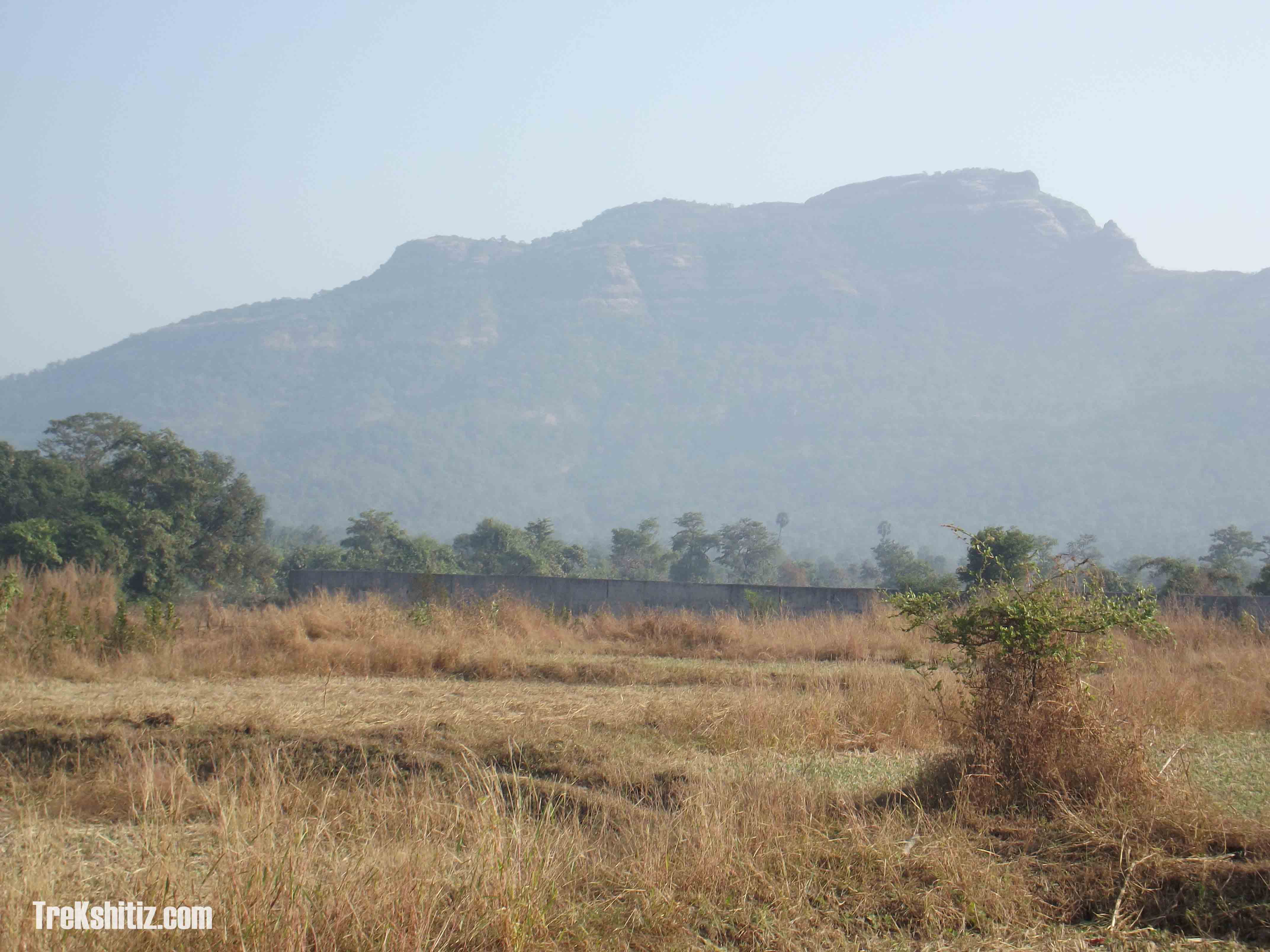
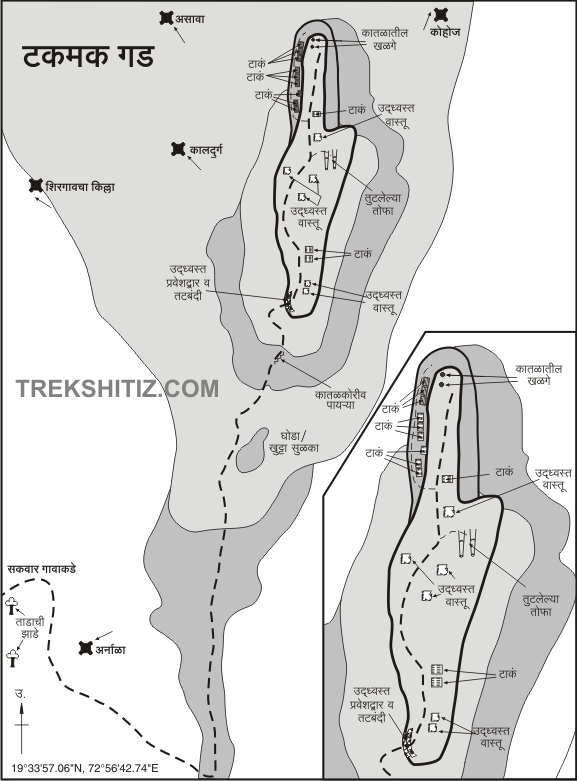
| From Sakwar village we can see the south part of Takmak fort (Nose). Facing the front, at right side, we can see the pinnacle also referred as �Ghoda� or �Khutta� and to the front side we can see plateau & hill range. We reach the plateau from the hill range. After turning back to �Ghoda� we enter into the fort through west fortification. In front of �Ghoda� there are steps carved in rock. Takmak fort is spread north-south. We enter the fort by crossing over the western walls. Here a path towards right takes us to the southernmost tip of the fort. This point is the one which we see from Sakwar village. This might have been an observation point as we get a good view of Sakwar and the surrounding villages. From this point, if we follow the same path back to the ramparts and proceed ahead, we come across twin cisterns which have been cleaned by Shridatta Raut and his team. The cistern on the right contains potable water. Beside the cisterns, we can see carved spots (which might be pillar bases) and a groove for overflowing water. After seeing the cistern when we go straight on the walking path, we view the remnant of houses which are hidden in trees. Later path divides: at right we observe the 2 bangle cannon. After seeing the cannon we reach the footpath which is again divided into 2 paths. One path takes you to edge of the fort and the other takes you to north plateau on fort. After descending from left we sees twin cisterns above the old historical cistern. Later on, we see the 2 bunch of 3 cisterns. All these cisterns were tried to be demolished by the British. Here water is not for drinking purpose. When we go to last cistern & descend from slippery path we observe the fortification rocks spread across. It is placed at north side of fort. From this edge watch tower spot can be seen. This is the place where the war between Maratha warrior and Portuguese took place, the Maratha warrior backed off and ran through the tunnel to reach the entry gate. The tunnel and entry gate is a mystery now a days. Way towards the entry gate has vanished due to dense jungle. But 2 cisterns can be observed on the way of entry gate. After seeing this part when we reach the main footpath towards the right one cistern can be seen, further on the plateau, a 2 ft. wide and 2 ft. height hole has been made in which water is poured from Pakhali, so that soldiers on the watch tower can drink water without any distant movement. From Takmak fort, we can see hill range of Kama on the south, Waitarana River on the west and Wandri Lake on the east. | ||
| Ways To Reach : | ||
| On Mumbai Ahmedabad highway (from Mumbai), Sakwar division is located on a distance of 84 km. At this division there is big board named �Waghad Gurukul�. After turning from right (500 meters) Sakwar base village is located. Behind this village, Takmak fort spreads over north -south. From Sakwar village, we can see the south part of Takmak fort (Nose), we can also see pinnacle on the right (front) side which is also referred as �Ghoda� or �Khutta� and later plateau & hill range. From hill range we can reach the plateau. For that we need to reach farms of Sakwar village. We can observe 2 heighted Palm trees. (In whole jungle these are the only 2 Palm trees). Out of which if we walk towards left Palm tree we reach the water Canal. After crossing that Canal in 5mins, we reach the same Canal. After crossing it we reach the Compound. After crossing that compound we reach the left Palm tree. Taking this route, we reach fort hill. From Sakwar base village it takes half an hour to reach base of the fort. After stiff climbing of an hour, we reach the plateau. After descending and ascending for an hour, we reach �Ghoda� pinnacle. After turning around to �Ghoda� we enter into the fort through west fortification. From Sakwar village it takes 3 to 4 hours to reach the fort. | ||
| Reaching Sakwar : | ||
| Get down at Vasai or Virar railway station, 6 sitter autos are available on sharing basis. Get down at Mumbai Ahmedabad highway after 10 kms, 6 sitters are available and they drop you till the Ramkrishna Math. From there, one needs to start walking to Sakwar village. (Vasai to Sakwar 23 km, Virar to Sakwar 22km). It�s easy to go from Vasai to Sakwar. | ||
| Accommodation Facility : | ||
| None | ||
| Food Facility : | ||
| Need to arrange | ||
| Drinking Water Facility : | ||
| Available in first cistern | ||
| Time To Reach : | ||
| 3 to 4 hours from Sakwar Village | ||
| Marathi Version |