| Fort Name : | Alphabetically | RangeWise | DistrictWise | CategoryWise | GradeWise |
| Madhu makarandgad | FortHeight : 4050 | ||
| Type : Hill forts | Fort Range : Mahabaleshwar | ||
| District : Satara | Grade : Medium | ||
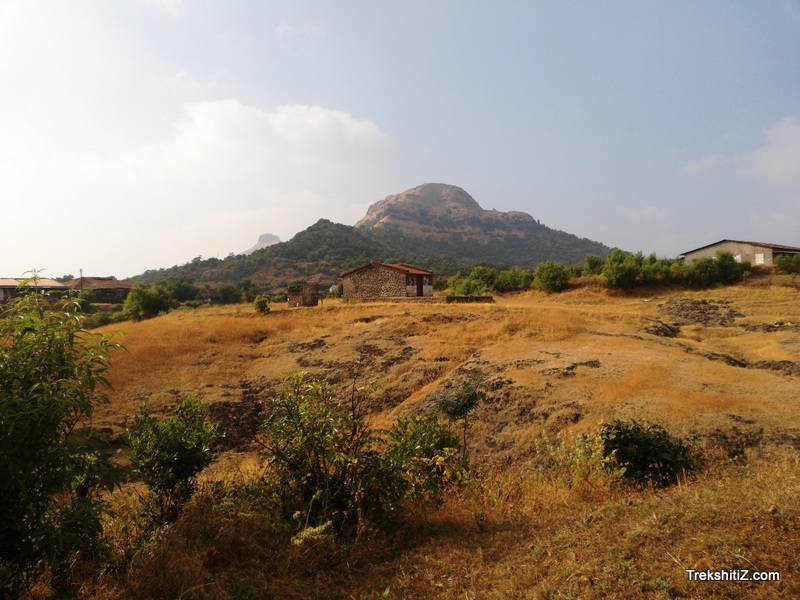
| When you are watching sunset from Mumbai point at Mahabaleshwar; the sun touches a hill that looks like a saddleback on a horse; before disappearing below the horizon. This hill, behind which sun sets down; is none but Madhumakarand. The twin forts - �Madhu� and �Makarand� sprawl in the east-west direction on the mountain range. The east mountain peak is Makarandgad and the west mountain peak is Madhugad. A valley pass was traversed in ancient times; from �Haathlot� village at the base of the Madhumakarand fort to the �Birmani� village of Ratnagiri district in Konkan. The Madumakarand fort was built to protect this passage. At the summit of the Madhumakarand fort is the village �Ghonaspur� where jangam people reside. People of this village are completely vegetarian. There is a sign-board at the temple which says that eating non-veg is not allowed in the village. The path leading to the summit of Madhu fort is difficult; so, for the safety; it is necessary to carry proper climbing equipment and ropes. |
|||
|
|||
| Fascinating Spots : | |||
| Two paths lead to Ghonaspur village that is situated at the summit of the Madhumakarand fort. One is through the Chaturbet village and the other is through Haathlot village. Both routes lead to the Mallikarjun temple of Ghonaspur. There are some worn out stones inscriptions depicting sacrifices of brave warriors in the battle (Veergali) and one in the remembrance wives of these brave warriors who sacrificed their live on the pyre of their brave husbands (Saati haat). This route from the side of the Mallikarjun temple leads to Makarandgad fort. A steep climb of 15 minutes along the hill edge, one reaches the decrepit doorway of the entrance to the fort. The doorway of the fort receives natural protection as it is carved in the stone. One of the paths, after entering from the doorway, leads to the summit of the fort and the second path going towards right circles around the fort hill to reach the back of the fort. About 10 minutes from the second path, we reach a water tank with pillars. Water in this tank is not suitable for drinking. Returning on the same path of the water tank, we can see steps heading to the fort�s summit. The steps are broken at many places, so placing your steps carefully makes you reach at the fort top in 5 minutes. There is a Mallikarjun temple with the statue of Nandi just outside the temple placed in the open. There is a dilapidated square structure in front of the temple. Stones of this structure are used to construct a memorial at this place. The backside of the temple does not bear any remains. We can see the Mahabaleshwar mountain, Chakdev hill, Madhugad, Rasaal Sumaar and Mahipatgad forts from Makarandgad fort. There is a dusty much traversed path to descend from the fort top. Amidst the path there is a unique rock that has a tunnel or hole formed due to weathering from wind and rain. Climbing down we reach the entry doorway of the fort. A route on the right side from this doorway is the one which had led us to the water tank; now walking left alongside the edge of the mountain, there is a dried-up water tank on the right. The same path leads to Madhugad. The track leading to Madhugad fort is destroyed one so carrying necessary trekking safety equipment and ropes is a must for reaching to the fort top. There is a large water tank on Madhugad fort. | |
| Ways To Reach : | |
| There are 2 routes leading to Madhumakarandgad fort 1) Chaturbet route: - Chaturbet village is 37 km from Mahabaleshwar. Starting on the Mahableshwar � Poladpur road; at around 15 km from Mahadeshwar; a forked road to the left; which holds an arch with �Ramvardayni mandir par� letters written on it. This road heads straight to chaturbet village. A cobbled rough road ahead goes to ghonaspur. This 4 km road can be travelled by vehicles like jeep or motorcycles, going straight to ghonaspur village at the summit (machi). There are ST buses from Mahabaleshwar to Chaturbet Mahabaleshwar � Vaalan 18.00 Mahabaleshwar � Kharoshi 15.00 Mahabaleshwar � Dudhgaon 14.30 and 17.00 (night stay) Getting down from the ST bus at the fork road it takes two hours walking towards ghonaspur village. Going from ghonaspur village from the Mallikarjun temple to the fort top takes about 45 minutes. 2) Haathlot route: - Chaturbet village is 37 km from Mahabaleshwar. Starting on the Mahableshwar � Poladpur road; at around 15 km from Mahabelshwar; a forked road to the left; which holds an arch with �Ramvardayni mandir par� letters written on it. This road heads straight to Haathlot village. (The fork road to Haathlot precedes the Chaturbet village). There is an overhead bridge on a stream ahead of Haathlot village. Crossing the bridge, climbing through the houses; we reach an open plain. Here one can see a noticeable route to the fort. There is a trail that goes through dense forest for about an hour and half or two hours and ends at the Mallikarjun temple at Ghonaspur village. One can reach the fort top from the temple in half an hour. The Mahabaleshwar � Haathlot ST bus leaves from Mahabaleshwar at 5 PM and its last stop is Haathlot for night stay. It leaves for Mahabaleshwar at 7 in the morning | |
| Accommodation Facility : | |
| 20 people can stay at the Mallikarjun temple | |
| Food Facility : | |
| Nil | |
| Drinking Water Facility : | |
| The water on the fort is not suitable for drinking. Water is available in Ghonaspur village. | |
| Time To Reach : | |
| 2 hrs - Hathlot route; Chaturbet route | |
| Best Season To Visit : | |
| Except rainy season. |
| Marathi Version |