Malegaon Fort
Maps & Routes
Explore detailed maps and trekking routes to reach the fort
No maps available yet
Browse All MapsIntroduction
Malegaon fort also known as Mahuligram fort is located on the confluence of Girna (Giriparna) and Mosam(Mokshini) rivers. Built in the 18th century, this fort now hosts a school inside its premises and is still in a good condition.
Historical Background
This fort was built by Nareshankar. The younger brother of the Chhatrapati Shahu II of Satara, Chatursingh declared a war against the Peshwas and took shelter in this fort. The Peshwa commander Trimbakji Dengle captured him inside the fort in a crooked way on 10th January 1810. After the Peshwas, Arabs had control over it. On 16th May 1818, British army attacked the Arabs, who 300-350 of them held the fort for a month’s period. On 10th June 1818, when the canon fired from the British exploded the pile of ammunition on the fort, the Arab defence went weak and they had to surrender on 13th June 1818.
Points of Interest
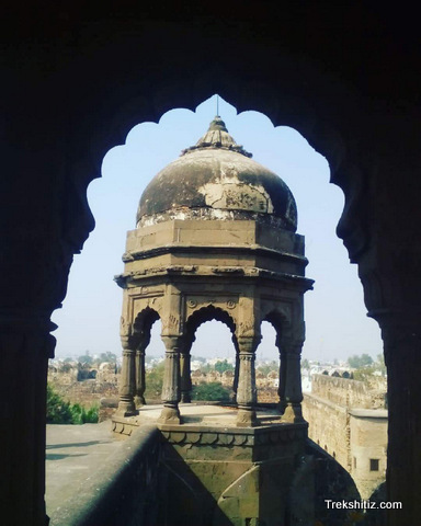
Having a trench on all its sides is very important for the security of any land fort and Malegaon fort has it on its four sides. By building a wall partition in the river, the water is diverted into this trench. There was a collapsible bridge built on this trench. Only one side’s trench is left presently, rest all have been wiped our due to increased colonization. The fort had three layers of fortified walls. The outside layer has lost in the housing colonies. Only one bastion to the river side is standing as of now. The fortified wall to the west has been cut to provide access for the Kankni Vidyalala School inside the fort premises. This is the main entrance of the fort. After entering, we can see the new school building and 3 canons in its front. Facing the school, one can see a space in the two fort walls from where the fort tour can be started. The inside fort wall is 20 feet high and has 9 bastions in it. On the fort wall there are narrow windows built and a place to stand. The second bastion which is on the outside does not have any bastion and is 15 feet high. There are narrow windows here too. Below the fort wall there are small rooms with dimensions of 2 X 2 X 3. The exact purpose of these rooms isn’t known. To circumvent tor fort between the walls it takes about 15 minutes. A door has been cut through the wall between two bastions for the school. Use the way between the school and the left bastion and proceed ahead. One comes across a huge entrance here. The wooden door is still intact. And is locked from outside. This 20 feet high door has two bastions besides it which have carvings of lotus on its arcs. There is a brick construction of about 10 feet high on the door and the bastions. There are 3 windows built on each door and the bastions. On the right side of the door there was a two storied structure and its top floor was dedicated for recreational and entertainment activities. Present day, the ground floor hosts the school and as the slab between the two floors have been collapsed the upper floor is inaccessible now.
Trek Duration
⏱️ 15 minutes from Malegaon S.T. bus stand.
Facilities & Amenities
Accommodation
Available at Malegaon
Food
Available at Malegaon
Water
Available at Malegaon
Best Season to Visit
🌤️ Throughout the year
Planning Your Trek?
Pack Smart
Carry essentials, water, and first aid kit
Start Early
Begin your trek early in the morning
Trek in Groups
Always trek with companions for safety
Keep Forts Clean
Do not litter on forts. Do not damage the fort.