Pimpla
Introduction
This fort is well known for its two needle holes, one of which is the biggest in Maharashtra. Pimpla or Kandala/Kandana fort is located in the Kalwan taluka of Nashik district and although its name is Pimpla, it’s far from the village of Pimpla. The base village of this fort is Malgaon Budruk.
Points of Interest
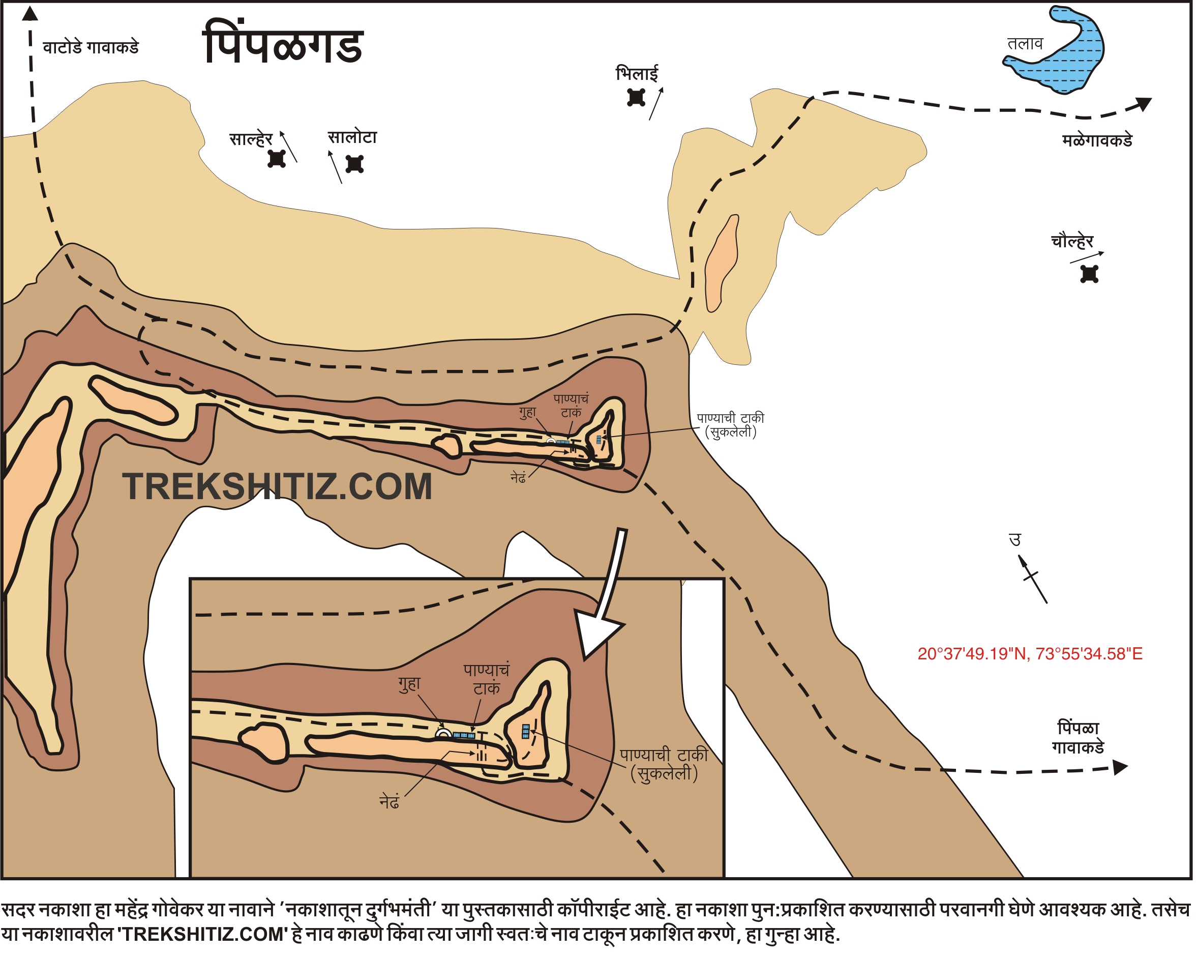
There are 3 ways to reach the fort. One from Pimpla village, second from Malgaon village and third from Vatode village. The route from Malgaon is comparatively easy and well in use. A path from the main road of this village goes towards the small dam and it takes about 15 minutes to reach here. One can reach here by a private vehicle too. The path is very next to the dam and beyond which is the ridge of a mountain. The point where the dam wall meets the path, there is a route to the left which takes us to the ridge of the mountain. After a 30 minutes hike on this route we come to a flat ground from where we can see Pimpla fort. The rock wall which is spread in south-north direction has the needle eye of the fort. While climbing from Malgaon, we can’t see the needle eye unless we reach the fort.
15 minutes walk from the open ground takes us to the base of the hill of the fort. From here, a bit steep hike for 15 minutes till we reach the rock wall which is spread in East-West direction, a path which is below the rock wall, turns to the right. As we move ahead on this path, keeping the mountain to our left and the valley to out right, we come across a point where the two rock walls meet. Next to it is the needle eye of the fort on the Soutn-North spread rock wall. There is a steep path going towards this needle eye. It takes about 1 hour 30 minutes to reach the needle eye from the base. On the lower side of the needle to the right, there are 3 rock cut water tanks. Above this there is a naturally formed cave and it is estimated that it may soon turn into another needle eye due to rock and soil erosion.
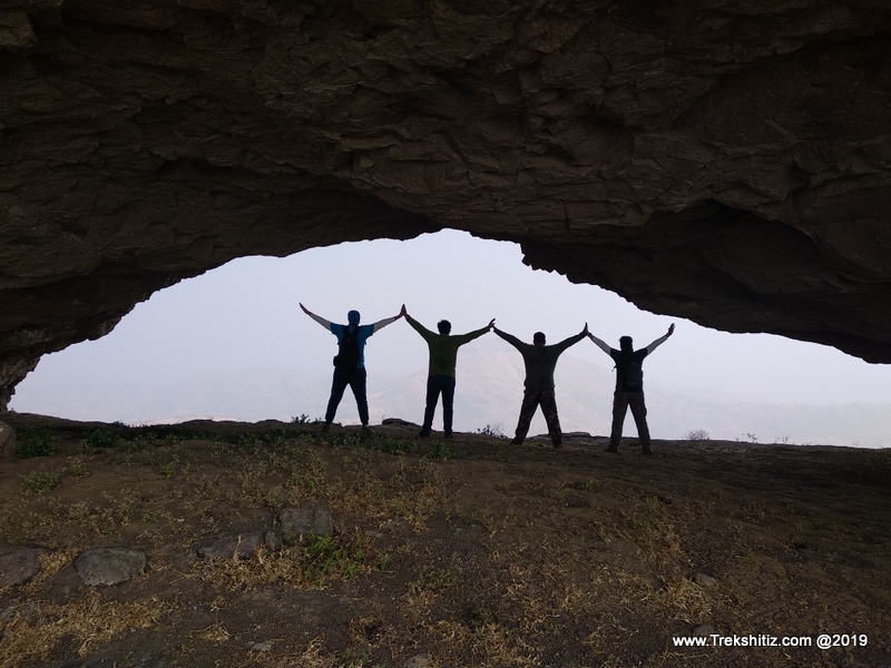
After this, one can enter the needle eye to experience the amazing view and soothing winds. Going forward from the needle eye to the left, we can see the two rock walls meeting. From this pass is the route to ascend the fort. After climbing here and once we reach the top, there are 3 rock cut water tanks which are now dried. Salher fort is visible from the top. After this, head back to the needle eye and cross it, where there is another route which circumvents the two rock walls and leads us to the needle eye again. On this route, we come across a wall which has been reinforced with cement plaster and has a painting of a goddess on it. Behind this there is a scripture carved in rock. The route coming from Pimpla village joins here.
How to Reach
One has to reach Nashik from where there are two routes to reach the base village of Malgaon.
1. On the Nashik - Vani Dindori road Malgaon can be reached by Nanduri - Kanashi - Chinchpada - Malgaon route which is about 238 kms.
2. Reach Kalwan via Devla on the Nashik - Satana road. From Kalwan transport is available to reach Malgaon which is 250 kms.
There are 3 routes to reach the fort:-
1. From Pimpla village the fort is very far and is not visible. One has to cross a hill and an open plateau to reach the fort base. It takes about 3 hrs 30 minutes by this route to reach the fort top.
2. From Vatode village it takes about 3 hours to reach the fort. Buses are available from Satana to reach Vatode.
3. From Malgaon it takes about 2 hours to reach the fort.
Facilities & Amenities
Accommodation
The cave on the fort can accommodate up to 10 people.
Food
Nil
Water
Nil
Best Season to Visit
🌤️ July to March
Other Forts in Chankapur
Planning Your Trek?
Pack Smart
Carry essentials, water, and first aid kit
Start Early
Begin your trek early in the morning
Trek in Groups
Always trek with companions for safety
Keep Forts Clean
Do not litter on forts. Do not damage the fort.