Salota
Fort Images
Explore Various Images of the Fort
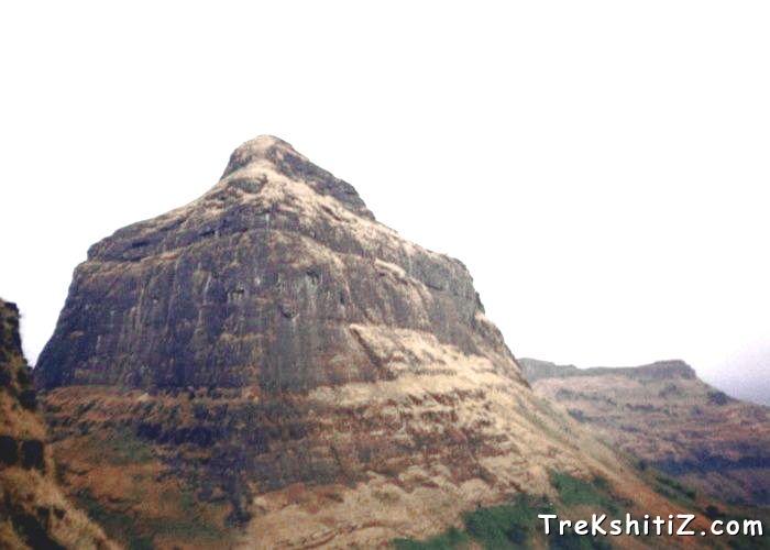
Salota From Salher
Maps & Routes
Explore detailed maps and trekking routes to reach the fort
No maps available yet
Browse All MapsIntroduction
The north - south range of the Sahyadri starts from Baalgan Baaglana in Nashik district. The range starting from north is called Selbari or Dolbari range. Mangi-Tungi Pinnacles, Nhavigad falls into the Selbari range while Salher, Mulher, Moragad, Hargad, Salota forts fall in the Dolbari range.
These forts are located on the border of dense forest of Daang region of West Gujarat and Baaglana region of Maharashtra.
Points of Interest
While ascending Salota one crosses three entrances. All these entrances are still in good condition. At the first entrance, towards right, there are two water tanks. At the last entrance, again towards right, there is one more water tank. The path from here takes us to the top of the fort through one more entrance. There are no remnants on the top of the fort. One can see a beautiful view of Salher from the top.
How to Reach
There are 3 ways to reach the fort:
1) Waghambe route:-
If coming from Mumbai / Pune one has to reach Tahrabad via Nashik- Satana. If coming from Gujarat, there is a road from Daang district to Tahrabad. At Taharabad there are buses, Jeeps available to go to Waghambe village via Mulher. After reaching Waghambe, head towards the cleft which falls between Salher-Salota and leads further to Salher. There is no water available on the route. The trail till the Salher-Salota cleft is tiring. It takes around 2 and half hours to reach the top of the fort through this route.
2) Maaldar route:-
This route goes through Maaldar village and is rarely used. One has to take a bus from Satana to reach Maaldar. This route passes through a cleft between Salher and Salota and takes around 3 hours to reach the top.
3)Salherwadi route:-
Salherwadi village is next to Waghambe village and can be reached via Satana - Tahrabad and Mulher. This route is very tiring and also there is no water available on the way. One has to cross 6 entrances and it takes around 3 hours to reach the top. There is a proper path to the fort and hence, there are less chances of losing way.
Trek Duration
⏱️ 45 minutes from Waghambe cleft.
Facilities & Amenities
Accommodation
Nil
Food
One has to arrange for their own food.
Water
Water is available throughout the year
Best Season to Visit
🌤️ N/A
Additional Information
1) It takes 3 days to visit Salher, Salota, Mulher, Moragad, Hargad.
2) Information on Salher, Mulher, Moragad, Hargad is available on our website.
Nearby Villages
Waghambe, Maaldar, Salherwadi
Other Forts in Balaghat
Planning Your Trek?
Pack Smart
Carry essentials, water, and first aid kit
Start Early
Begin your trek early in the morning
Trek in Groups
Always trek with companions for safety
Keep Forts Clean
Do not litter on forts. Do not damage the fort.