Sondai
Introduction
Karjat is one of the favourite destinations for trekkers. This is a central location for trekkers to visit places like Rajmachi, Peth, Songir, Peb, Irshalgad, Bhivgad, Dhak and Bhimashankar. Sondai, a relatively less known popular fort is also within reach. This fort is a part of the Matheran range. Though it does not have any structural remnants, the scenic views it offers and the final 15ft of rock patch makes it a thrilling experience. This fort was supposedly built as a watch Tower.
Points of Interest
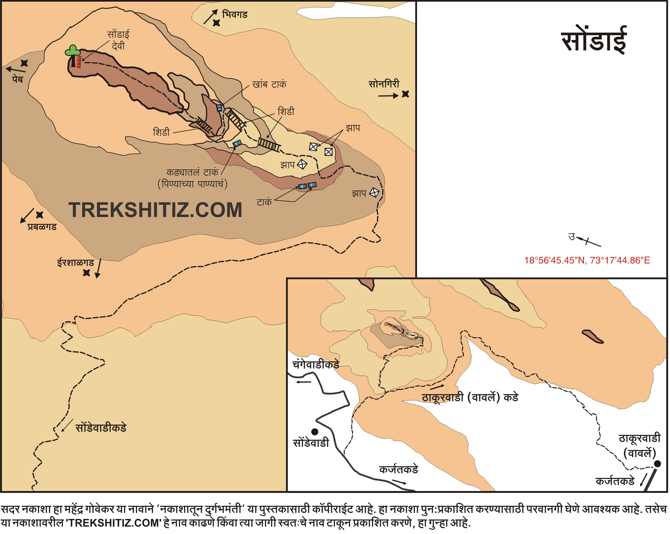
Sondewadi and Vavarle are the base villages of Sondai fort. Sondewadi village is situated at 1/4th height of this fort. The pathway from this village goes to the fort which takes 15-20 minutes to reach to the plateau. Here we can see the route coming from Vavarle village. From here we can see 2 flag posts at the top of the fort (from one of this flag post, i.e. at the cliff of rock patch, one can reach to the top with the help of ladder which is kept there). Further there is carved steps in rock.
From Sondewadi, it takes 45mins to reach the second plateau.
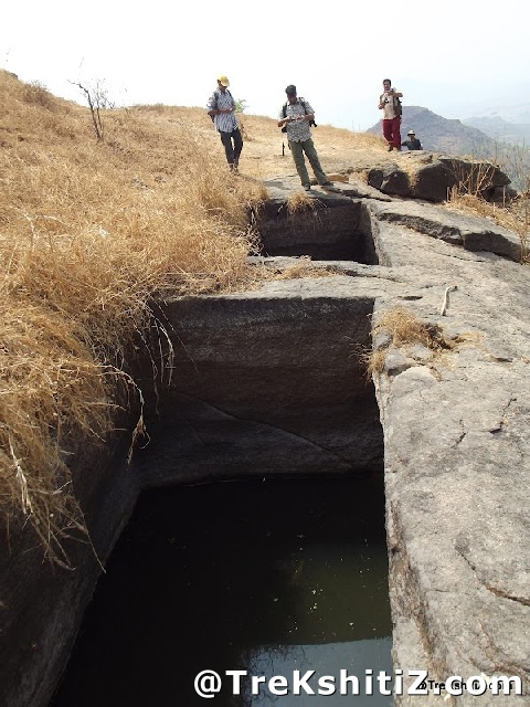
Here exist the two adjoined cisterns which are carved in rock and hold water all year round. But in summer the water level falls and we can pull out water using rope. From here we can see neighboring Gavari hill which seems taller than this fort.
At the upward side of the plateau carved steps are there. After climbing them, at the left side we can see the dried cistern while at the right side, there has a ladder to ascend. We should remove our footwear here and move forward to the summit. (This is a sacred place dedicated to Sondai Devi and it is recommended to respect the beliefs of the locals). There are footholds as well a ladder to climb to the summit.
After climbing this rock patch, at the right side there are two cisterns, in which one is a big with two rock pillars in it and its water is not potable. Second cistern is small compare to the first one. There is not much place to move around at the top of the fort. Here we can see two-three carved idols which are placed under the tree. One of it is Sondai Devi’s idol/statue. From the top we can see the Matheran Mountain Range, Morbe Dam, Vavarle Dam and nearby surroundings.
How to Reach
There are 2 routes to reach to the Sondai fort.
Trek Duration
⏱️ 2 hours from Sondewadi, 3 hours from Vavarle
Facilities & Amenities
Accommodation
No accommodation facility on the fort, but the arrangements can be done in the schools of Vavarle Thakarwadi and Sondewadi by asking the villagers.
Food
Food arrangements have to be made by our own or in Karjat village.
Water
Cisterns on the fort are a source of drinking water all year round.
Best Season to Visit
🌤️ N/A
Additional Information
1. In rainy seasons, don’t rely on the carved sockets or the ladder. Carry your own rope (at least 30 ft.) for more safety.
2. In summer, carry your own rope to pull out the water as the water level of these cisterns goes down.
3. To climb up use the Sondewadi route and to climb down use the Vavarle route. This is because from the top of the fort Vavarle village and surroundings can be easily seen so there are fewer chances to stray.
Nearby Villages
Sondewadi, Vavarle
Other Forts in Matheran
Planning Your Trek?
Pack Smart
Carry essentials, water, and first aid kit
Start Early
Begin your trek early in the morning
Trek in Groups
Always trek with companions for safety
Keep Forts Clean
Do not litter on forts. Do not damage the fort.