Mangalgad

Introduction
Mangalgad or Kangorigad is one of the forts situated in the dense valley of Jawali. Valley of Jawli comprised of dense forests, huge mountains & deep valleys in the medieval period, which made this region impregnable. Jawli is surrounded by Mahabaleshwar, Makarandgad, Mangalgad, Chandragad, Pratapgad, Kawala Fort & Parghat. “More” Dynasty ruled this valley for generations.
Mahad was a main trade center then. Goods unloaded in Mahad were dispatched to various places through the different trade routes. To keep an eye on these trade routes forts are built on the Western Ghats and Konkan. Mangalgad was built to safeguard the trade routes of Bhop Ghat, Varandh Ghat & Aswal Khind.
Historical Background
Chandrarao More built Kangorigad in the valley of Jawli for safeguarding the trade routes. On 15th January 1656 Shivaji Maharaj attacked and seized Jawli. With this victory he got the forts of Kangorigad, Dhawalgad & Rayri, and a brave warrior like Baji Prabhu Deshpande. After restoring Kangorigad he renamed the fort as “Mangalgad”. Due to its easy accessibility from Raigad, it was used to imprison political criminals. After killing Sambhaji Maharaj, Aurangjeb sent Itkadarkhan aka Zulfikarkhan to capture Raigad. In March 1689, Zulfikarkhan seized all the area & forts surrounded by Raigad to block the ways to Raigad, including Mangalgad. In 1690 Ramchandrapant, Minister of Chatrapati Rajaram Maharaj took over Mangalgad. In 1817 Baapu Gokhale arrested Colonel Hunter & Morrison of Madras regiment & imprisoned them on Mangalgad. In 1818 Colonel Prother captured this fort.
Points of Interest
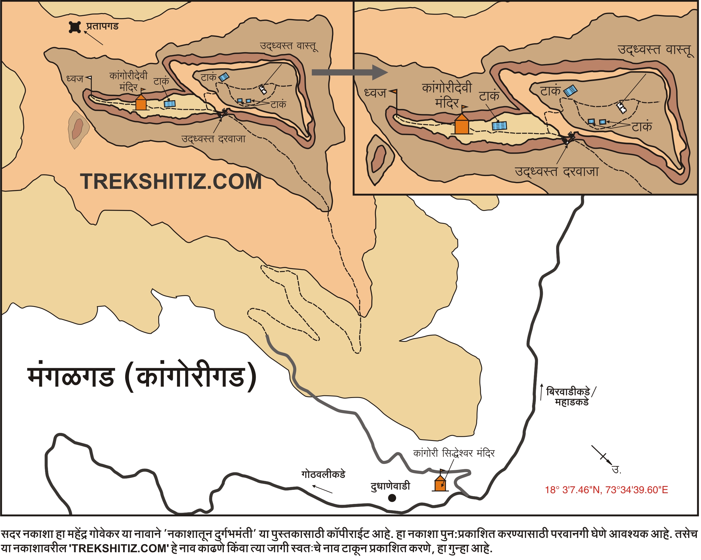
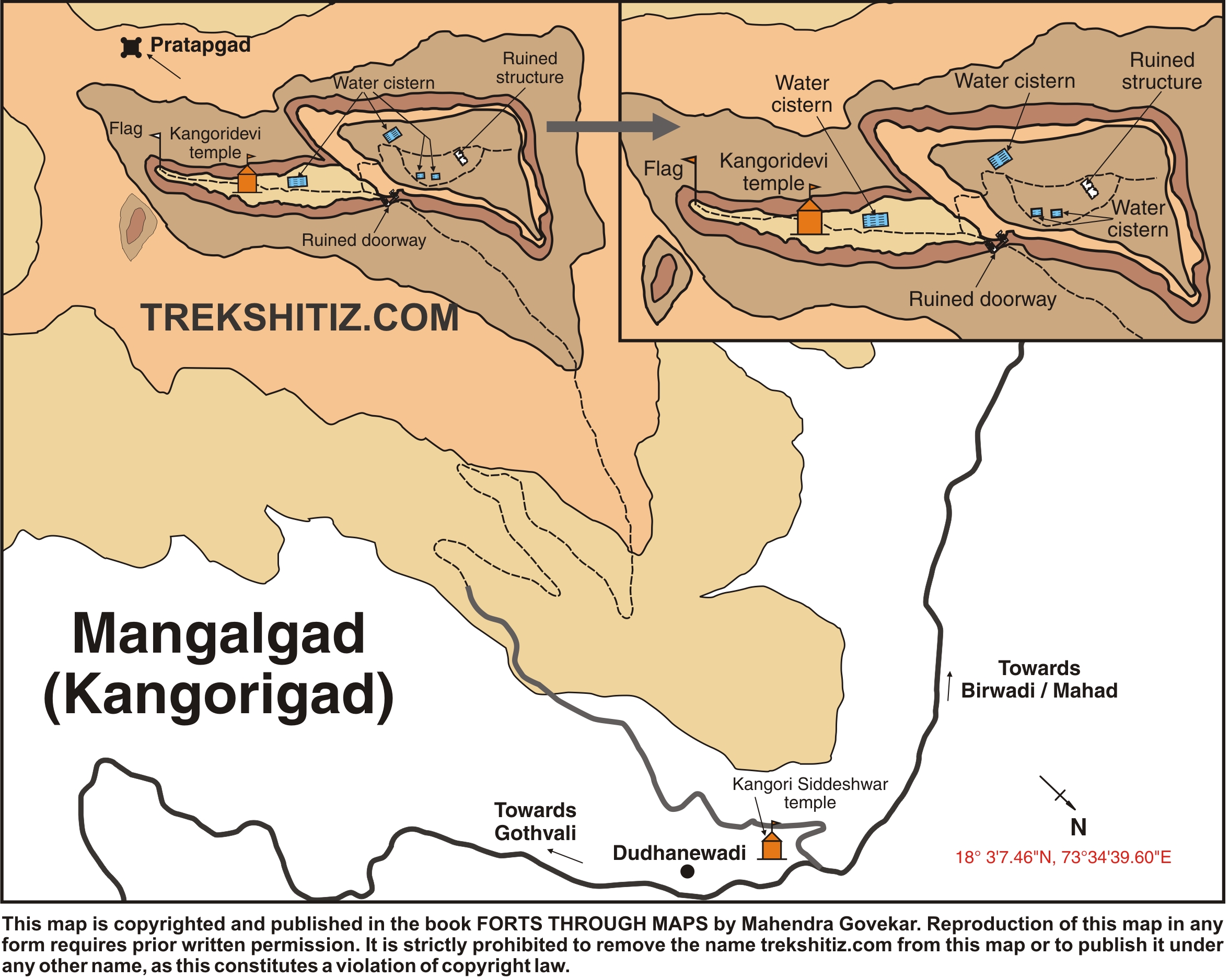
Mangalgad is stretched 1485 ft East-West & is 264 feet wide in North-South direction. Its main entrance is destroyed, but remnants of the adjacent bastions & ramparts are still there. After entering, if you take right then you will reach to the citadel. The way to the left takes us to Machi, on which you will see the temple of Kangori Devi. While going towards this temple at the right hand side you will see one rock-cut water cistern with steps to enter.
At the left hand side a dry tank is there. The idols found on this fort are kept near this tank. Kangori Devi's temple is built in the rock platform. The roof is destroyed, but the remnants on entrance are there. The idols of deities Kangori Devi and Lord Bhairav are found here.
Behind the temple is the end point of the fort from where we can have a glimpse of the surrounding region. Here we can see a bastion with flag post.
As we move towards the citadel, we can see a narrow tank towards the cliff and a big tank on the top of the citadel. Here we can see the remnants of 2 mansions. Behind these mansions lies the east most point of the fort, with a prominent bastion. While ascending the fort, this point is always in sight. There are two more tanks here which contain potable water all the year.
How to Reach
To reach Kangorigad, one has to board the Thane-Pimpalwadi ST Bus & get down at Dudhanewadi/ Kangorigad stop. Near that stop, you can see the temple of Kangori Sidhheshwar & it is besides a hill. Behind this temple, the way to the right, around the boundary of a field, will lead to the top of the hill within 30-45 minutes. Once we reach here, we can see the western bastion of the fort in front. We need to ascend in this direction. After climbing a small rock patch, we can walk on the way to left to reach the entrance of the fort. This is bit steep.
There is another way to this fort. In front of Kangori Sidhheshwar temple there is a field, and a steep hike from here takes us in less time to hill top. However, this way might be tiring being more steep. This way can be used while descending the hill.
If you don't get the Direct Pimplwadi Bus from Thane then you have to go to Mahad. From Mahad you need to go to Birwadi. There you will get Birwadi-Pimplwadi Bus in every two hours. Jeeps or Rickshaws (10 Seaters – Rs.20/- per person) are also available from Birwadi to Dudhanewadi.
Trek Duration
⏱️ 2 Hours via Dudhane Wadi.
Facilities & Amenities
Accommodation
10 People can be accommodated in the temple except for the rainy season.
Food
None
Water
Available
Best Season to Visit
🌤️ N/A
Additional Information
Bus Time-Table:
Depot Village From Depot From Village Km
Birwadi Pimplwadi
(Mahad)
Thane Pimplwadi
Other Forts in None
Planning Your Trek?
Pack Smart
Carry essentials, water, and first aid kit
Start Early
Begin your trek early in the morning
Trek in Groups
Always trek with companions for safety
Keep Forts Clean
Do not litter on forts. Do not damage the fort.