Tandulwadi
Fort Images
Explore Various Images of the Fort
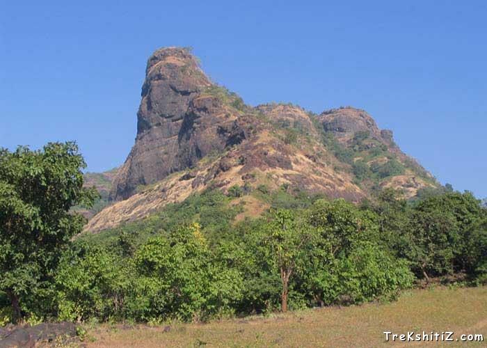
Tandulwadi fort from base village Tandulwadi
Maps & Routes
Explore detailed maps and trekking routes to reach the fort
No maps available yet
Browse All MapsIntroduction
Tandulwadi fort is situated about 4.5 km away on north east side of Saphale Road station on Western Railway. This fort is one of the most beautiful spot for mumbaikars to visit in one day.
Historical Background
One can see the history of the fort in Thane Gazetteer: It states the following
Tandulwadi fort is situated 16km away from Kelve Mahim, at a height of 571meters (nearly 1900 feet) from MSL. Tandulwadi fort is situated at around 4.87 km on north east of Saphale station. In 1737, this fort was captured by Marathas. On the top of the fort, one can find many water cisterns dug in the rocks, water reservoirs and remains of ramparts. Vaitarna River flows to the east of this hill. At the banks of this river a small village called Lalthane is situated. There is a water pond in Lalthane believed to be built by the Portuguese.
In thirteenth century, King Bhimdev’s kingdom comprised the cities of Shurparak (Nalasopara) and Mahikawati (Mahim). In 1454, Sultan of Ahmedabad captured Mahikawati. One Bhadurshah conferred the responsibility of Tandulwadi to a Mallik Allauddin. Later the fort was in the hands of Portuguese and then the Peshwas.
Points of Interest
There are remains of the fortification as we reach to the top. There is a square shaped water pond on the top of the fort. If we descend a bit on path which comes from the western side, one can find many rock-cut water cisterns. There is no water in any of these cisterns after monsoon. On this fort one can find herbs with medicinal values and different species of birds.
How to Reach
To reach Tandulwadi fort one can get down at Saphale Road Station on western Railway. From here one can take State Transport / shared jeep to Tandulwadi village. It takes about half an hour to reach a school which is at the base of the fort. From here, we can start our ascent.
The other way to the top of the fort is through Rodkhad Pada in Saphale.
Trek Duration
⏱️ 2 hours from Tandulwadi village to the top
Facilities & Amenities
Accommodation
None on the fort
Food
Trekkers suggested carrying packed food
Water
Available in water cisterns
Best Season to Visit
🌤️ All the year, a good monsoon trek
Nearby Villages
Tandulwadi, Lalthane
Other Forts in Palghar
Planning Your Trek?
Pack Smart
Carry essentials, water, and first aid kit
Start Early
Begin your trek early in the morning
Trek in Groups
Always trek with companions for safety
Keep Forts Clean
Do not litter on forts. Do not damage the fort.